
Brett Sandercock holds an Upland Sandpiper outfitted with a GPS tracking tag before release at Konza Prairie, Kansas. / © Brett Sandercock
NORWICH, VT – Five to seven days of nonstop flight across an ocean, between continents. This mind-bending feat of endurance is undertaken twice each year by Upland Sandpipers (Bartramia longicauda) migrating between North and South America. For those of us who gear up for a two-hour car ride (complete with map and weather reports, coffee, snacks, and a queue of podcasts), a 20,000 km (~12,500 mile) annual journey seems almost impossible to comprehend—especially when you consider that sandpipers are carrying nothing but the feathers on their backs.
Biologists have long known that Upland Sandpipers migrate between breeding grounds in the northern United States and Canada to wintering grounds in the Pampas ecoregion of Uruguay and Argentina, but via which course and exactly when they traveled remained a mystery… until now. A recently published paper in the Open Access journal Frontiers in Ecology and Evolution unveils surprising new information about the species’ migratory patterns.
In a first for this species, researchers from the Vermont Center for Ecostudies and the Norwegian Institute for Nature Research, with support from the U.S. Department of Defense Legacy Resource Management Program, used lightweight satellite tracking tag data (and dynamic Brownian bridge movement models) from nine Upland Sandpipers breeding in Kansas and Massachusetts to describe a series of new discoveries.
The team learned that sandpipers regularly crossed major ecological barriers during migration, including long oceanic flights, high elevation mountains, and tropical forests. New staging sites at canefields in the mountain valleys of Colombia, grasslands in the Llanos of Venezuela, and at airports (e.g., Baltimore Washington International Airport, Maryland) along the Atlantic Coast of the U.S. were documented. Additionally, the researchers noted that unlike many bird species who overwinter in a single location, individual Upland Sandpipers used multiple discrete areas up to 1,500 km apart on nonbreeding grounds. Other noteworthy results include the discovery that a sandpiper tagged in Massachusetts overwintered in Brazil less than 100 km away from another sandpiper tagged in Kansas; and two sandpipers that were captured 27 km apart in Kansas overwintered ~2,600 km apart from each other in central Brazil and Uruguay.
Perhaps the most dramatic discovery, however, came from the Amazon rainforest. “I don’t think anyone, including us, would have confidently predicted what we discovered: some of these Upland Sandpipers—a species thought to inhabit large open grasslands exclusively—spent the nonbreeding season on partially flooded river islands in the Amazon basin,” noted author Jason Hill. Hill added, “Just as extraordinary, this area is almost 1,000 km north from the nearest site previously known to host overwintering Upland Sandpipers. Taken together, we hope this suite of discoveries moves the needle forward substantially in terms of adapting and improving the global conservation strategy for this shorebird species.”
The article, “Migration Patterns of Upland Sandpipers in the Western Hemisphere,” is freely available online on the Frontiers in Ecology and Evolution website. In addition, all of the raw and processed tracking data are freely available for the public to view, and other researchers to use, at Movebank.org.
Funding for this research project was provided by the U.S. Department of Defense Legacy Resource Management Program (Project 15‐764).
—END—
Images Available for Use
(Click on image for full resolution)
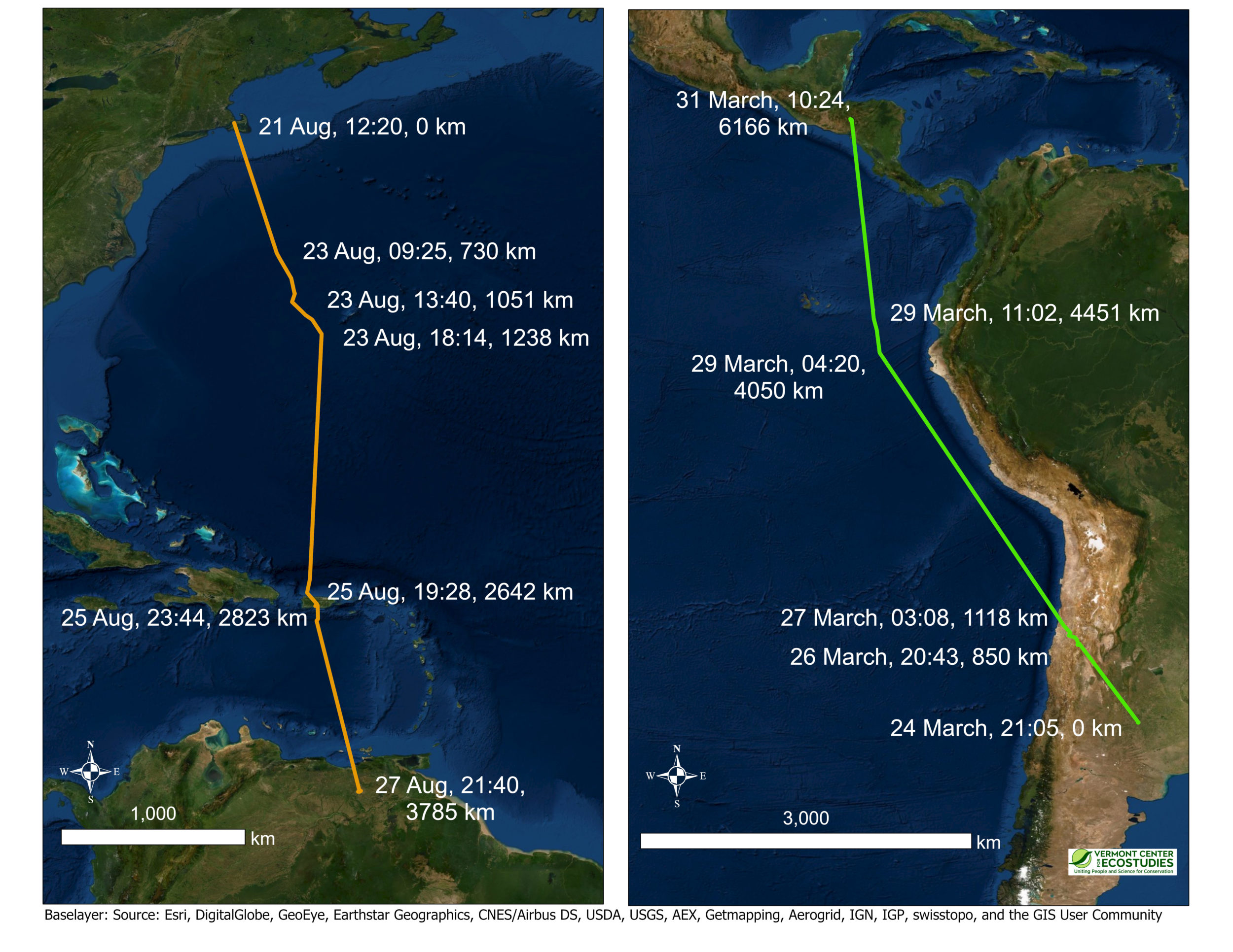
Two examples of migratory segments illustrating nonstop flights over long distances for multiple days by Upland Sandpipers wearing satellite tags. Extreme migratory movements included a southbound flight of 3,785 km in a 6-day period over the Atlantic Ocean from Massachusetts to Venezuela (left panel), and a northbound flight of 6,166 km in a 7-day period across the Andes and along the Pacific coast from Argentina to Honduras (right panel). Annotated values for a subset of fixes in the figure include the date, time (in UTC), and the cumulative distance traveled (km).
–
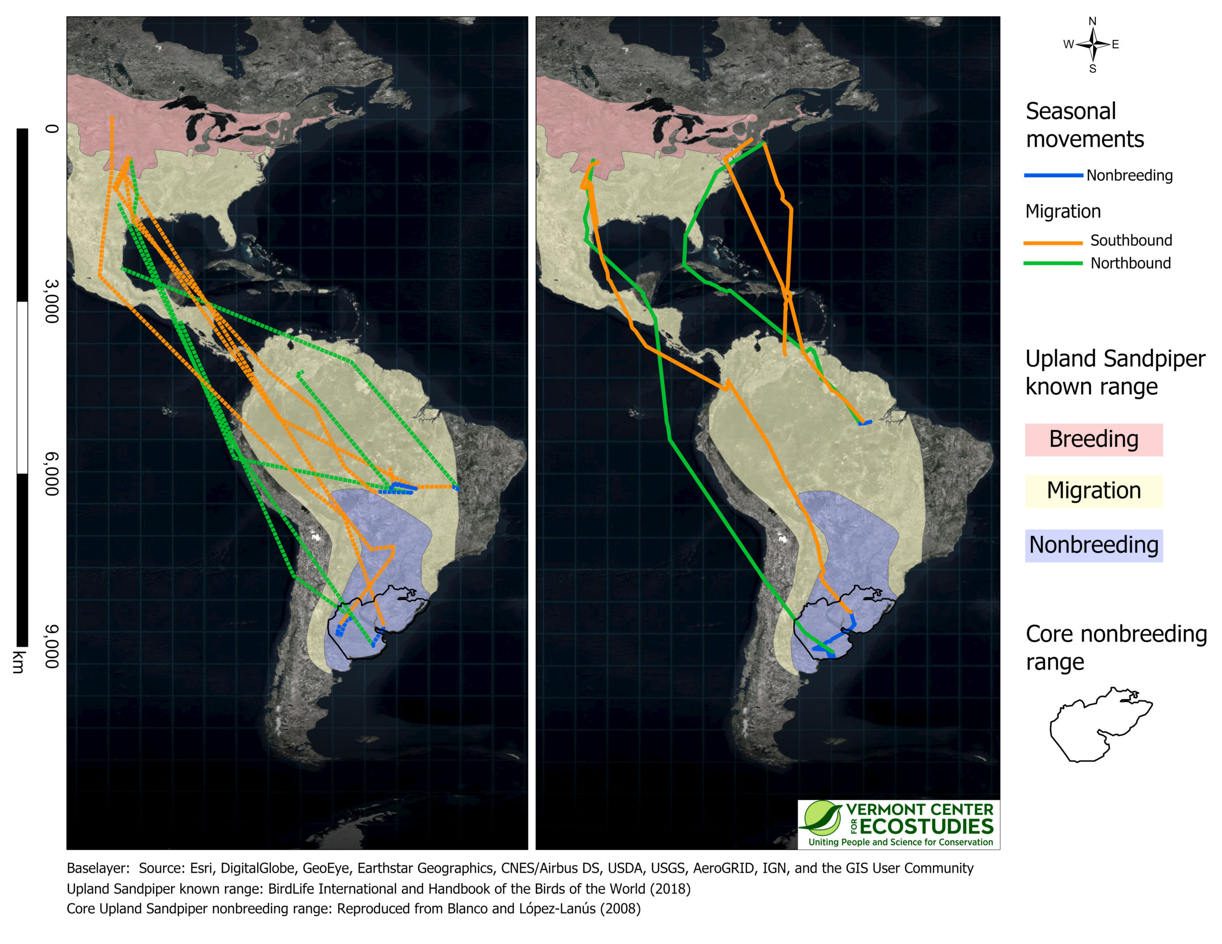
The annual movement paths of nine Upland Sandpipers captured in Kansas or Massachusetts and tracked with GPS (left panel, dashed lines, 5 birds) or solar-powered PTT tags (right panel, solid lines, 4 birds). Movement paths include southbound migration in autumn (Aug-Nov, orange), winter movements (Dec-Feb, blue), and northbound migration in spring (Mar-May, green). Colored semi-transparent polygons are the known breeding, migration, and nonbreeding range of Upland Sandpiper from BirdLife International and Handbook of the Birds of the World (reproduced with permission). The core nonbreeding range (black polygon, both panels) represents the area that is considered to have the greatest density of Upland Sandpipers on the nonbreeding grounds (reproduced with permission from Blanco and López-Lanús, 2008; https://sora.unm.edu/node/133519).
–
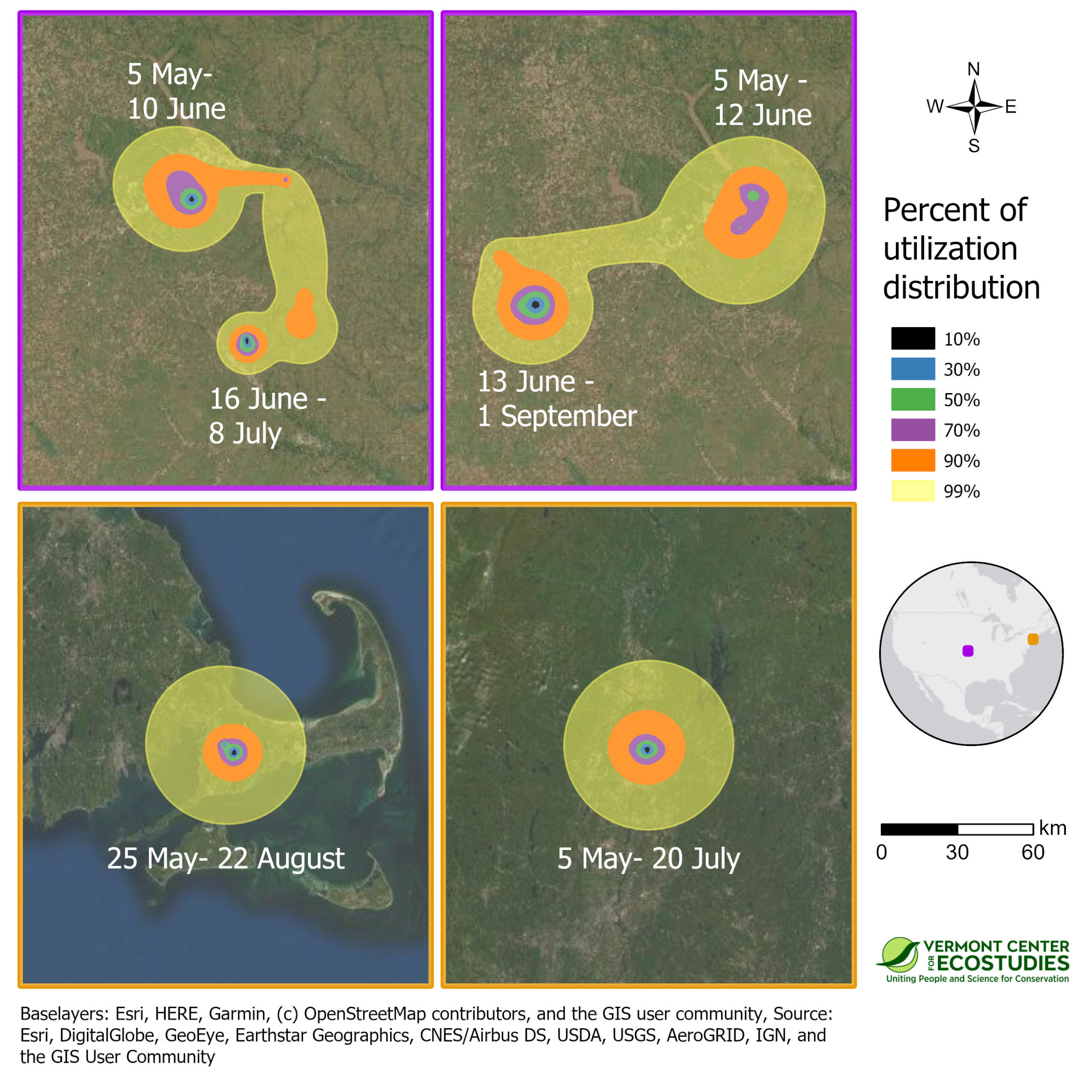
Space use on the breeding grounds during the summer of 2016 for four sandpipers marked with PTT transmitters at tallgrass prairie sites in Kansas, and prairie remnants in Massachusetts. Approximate 99% utilization distributions indicate probability of use for each sandpiper throughout the breeding period, and were calculated using dynamic Brownian bridge movement models. The border color of a panel indicates its location on the inset map, and all panels are shown at the same spatial scale.
–
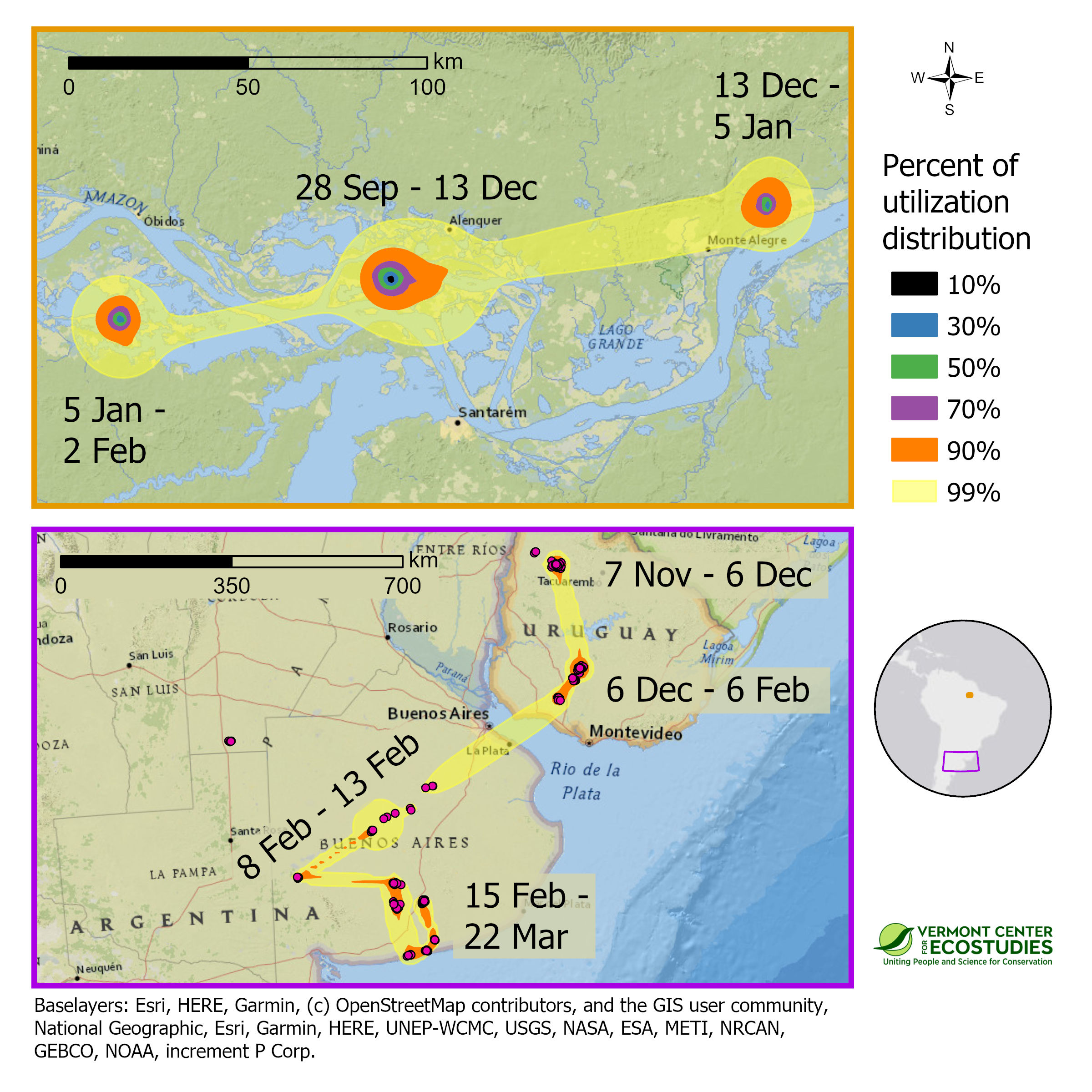
Space use of two Upland Sandpipers, marked with PTT transmitters, at nonbreeding sites in South America during the winter of 2016-2017. One sandpiper from Massachusetts wintered on a network of islands along the Amazon River in Brazil (top panel), whereas one sandpiper from Kansas overwintered in Uruguay and northern Argentina (bottom panel). Approximate 99% utilization distributions indicate probability of use for each sandpiper during the nonbreeding period, and were calculated using dynamic Brownian bridge movement models. Note that scale bars differ between the two panels. Border color of the panels indicates their location on the inset map.
–
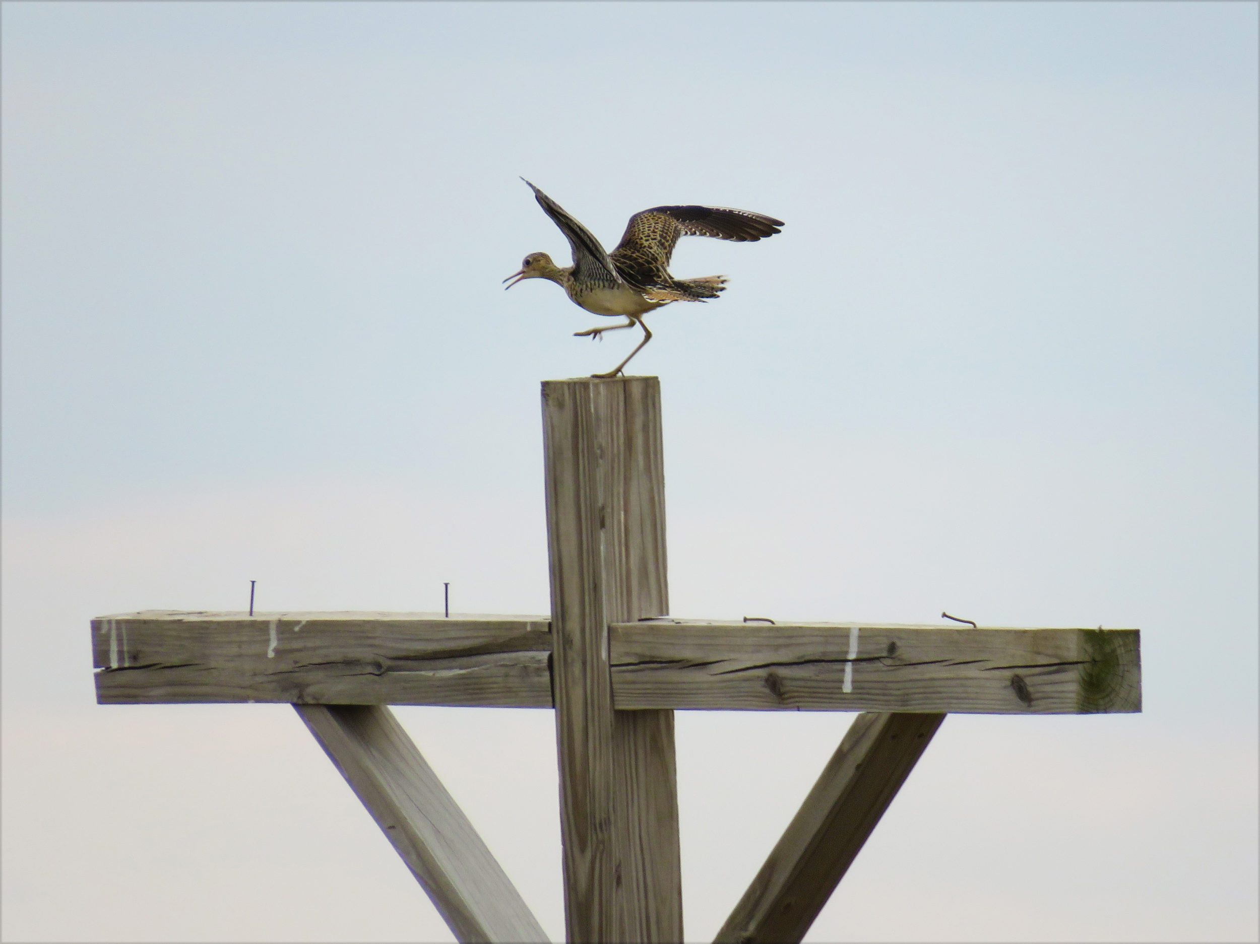
An Upland Sandpiper alights atop a utility pole at Fort Riley, Kansas. / © Jason Hill