
Jason Hill, Brett Sandercock (Kansas State University), and Clay Graham prepare to release an Upland Sandpiper wearing a solar-powered GPS tag at Konza Prairie, Kansas. © Jason Hill
It is well known that Upland Sandpipers (Bartramia longicauda) migrate thousands of kilometers to their wintering grounds in South America, and convention holds that they only use upland habitat en route. They certainly don’t fly over big cities (e.g., Baltimore, MD; Raleigh, NC; Fort Worth, TX), cruise non-stop over the Atlantic Ocean for three days, cohort on steep mountain slopes, hang out on Neotropical river banks for the winter, or spend months at one of our nation’s busiest airports, right? Well, not so fast: VCE’s recent research has shown that Upland Sandpiper habitat use is in fact much more interesting and complex than we previously realized.
Birders tend to look for migrant Upland Sandpipers in large expansive grasslands with few trees, and Upland Sandpipers certainly use these landscapes. But our tracking efforts have revealed that this species uses a much greater diversity of habitat, including savannah-like mountainside grasslands, agricultural fields, even golf courses and suburbia. Over the last two years, we’ve deployed nearly a dozen satellite tags on Upland Sandpipers in collaboration with the Department of Defense Legacy Resource Management Program. A few of these tags are solar-powered, and they are still providing daily location data for two sandpipers (currently in Brazil and Uruguay, respectively).
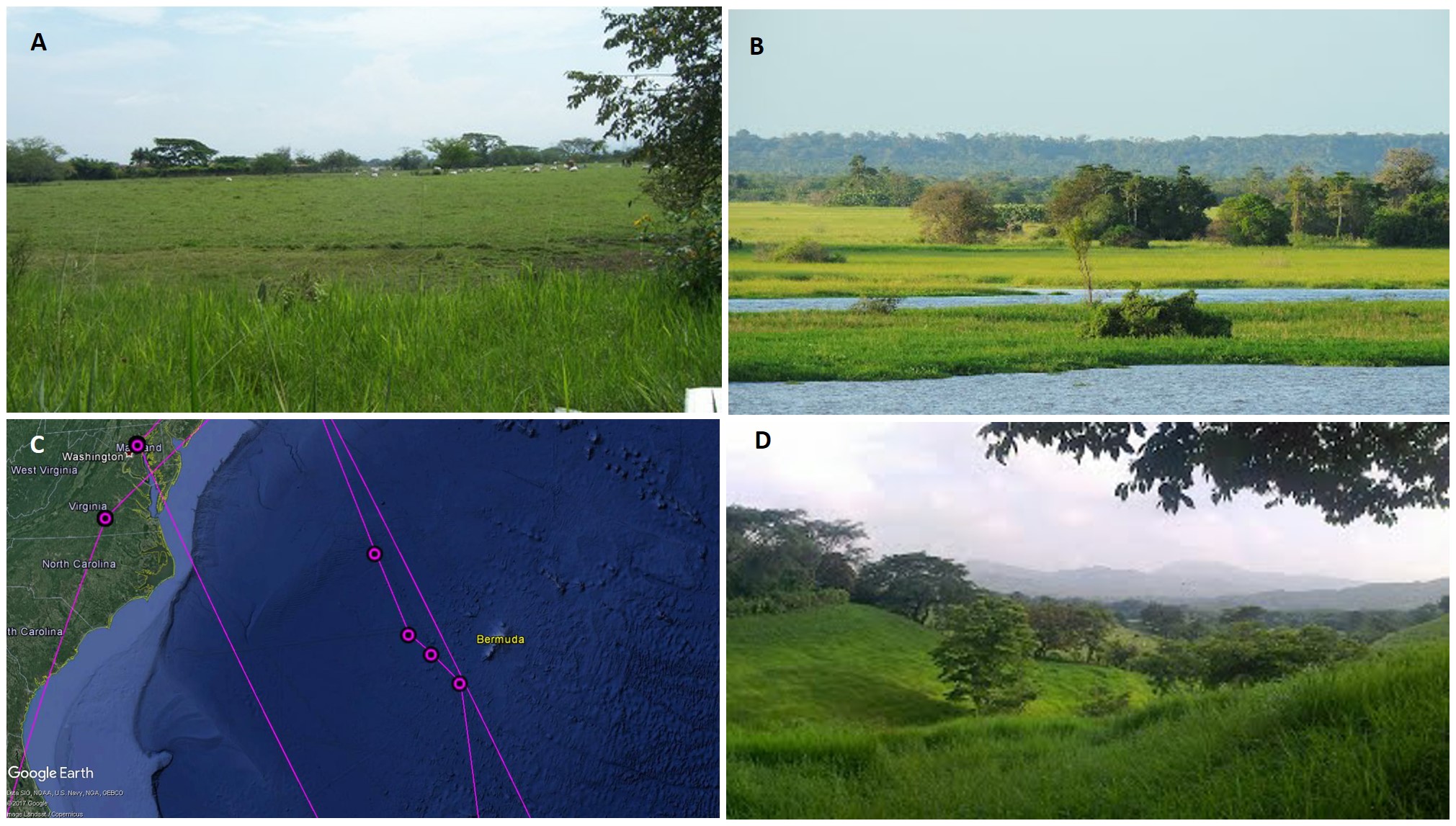
A slice of life: GPS tags reveal diverse habitat use by Upland Sandpipers. All photos show locations of similar habitat near areas used by Upland Sandpipers on their migration to South America. A) Pastureland with cattle near Cali, Columbia. B) Edge of the Amazon River, Brazil, which is underwater in some years (photo by Érico Christmann). C) Upland Sandpiper locations (dots) and probable flight paths (lines) across the Atlantic Ocean. D) Mountain savannah near El Sabino, Chiapas, Mexico (photo by Eduardo Sanz (ESGAGroup)
Why is it important to understand the full suite of habitats used by Upland Sandpipers? This species has declined precipitously throughout its North American breeding range over the last half century; in Vermont, Upland Sandpipers now likely breed only in the Champlain Valley, and sparingly at that. Preserving large swaths of open grasslands for breeding is certainly a priority, but we must also unlock the mysteries of the species’ migratory and winter ecology: where do they go, how do they get there, and what habitats sustain them along their journeys and on the wintering grounds? Our research at VCE is intent on answering those questions, and we look forward to sharing new discoveries as they emerge.

The fall 2016 migration route (>10,000 km, so far) of an Upland Sandpiper that bred in Kansas. This Upland Sandpiper was fitted with a solar-powered satellite tag in April, 2016 at Konza Prairie, Kansas. Since leaving Kansas in July, she has visited nine additional countries on her southward journey. Map created in ArcGIS.