We can’t blame it all on COVID-19, because off-trail hiking in the Catskill Mountains (and elsewhere) has been steadily increasing in popularity for decades. In contrast to established hiking paths, off-trail (AKA bushwhacking) hiking involves finding your own way up a mountain. Historically, bushwhackers had to be highly skilled at backcountry orienteering to summit these trailless peaks. In the age of the internet however, the hurdles to bushwhacking are considerably lower, and there are many websites with accessible step-by-step route instructions for anyone with a smartphone to use. In the Catskills, there are 17 trailless peaks over 3,500 feet, and the growth of these informal trail networks is readily apparent from remote sensing data and summit canister registries. Over the last decade, the number of off-trail hikers on these 17 peaks has increased by 3-10 fold. The growth of the informal trail network in the Catskills has even alarmed members of the off-trail hiking community, who have reached out to the NYDEC with their concerns.
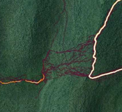
Pine Roehrs, Senior Natural Resource Planner at the NYDEC and first author of the above NYDEC report, was one of the first to document the extent of these trailless hiking networks using Strava heat maps. Strava is a fitness app that tracks the movements of its subscribers and makes its users’ (anonymized) data viewable on the web. The Strava heatmap image below shows part of the Devil’s Path hiking trail (bright yellow line on the right side of the image) into the Hunter-west Kill Wilderness of the Catskills. The faint purple lines are where individual hikers left the trail to bushwhack up to the summit of North Dome. Once at the top, bushwhackers follow the ridgeline west to the trailless summit of Mt. Sherrill (orange line on the left of the heatmap).
These delta-like unofficial hiking trail networks are generating concerns about erosion, water quality, ground vegetation die-back, backcountry safety, and wildlife impacts. To date, no studies have examined the role of off-trail hiking on wildlife in the Northeastern United States (to the best of my knowledge), and only one study has directly assessed the influence of hiking trails on the abundance and reproductive success of montane birds in our region. That study looked at Blackpoll Warbler populations in the White Mountains of New Hampshire and found little evidence of hiking trail effects on Blackpoll Warblers. Might we expect birds to respond differently to a mosaic of hiking paths, as shown in the above image via purple lines? As an analogy, living adjacent to a highway (like I do) has downsides, but our family mostly tolerates the predictable noise pollution at certain times of the day. If cars started randomly driving through our yard, however, that would be a level of disturbance that would likely force us to move from our home.
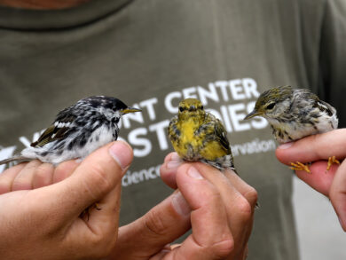
Blackpoll Warbler trio caught on Mount Mansfield, VT ©Michael Sargent
With that roadway analogy in mind, people from the NYDEC, the NY Natural Heritage Program, and VCE came together to consider the potential impacts of unregulated hiking behavior on montane birds in the Catskills. We designed a research project around VCE’s Mountain Birdwatch program, coupled with bird surveys conducted at off-trail locations with both low and high levels of off-trail hiker use. With funding provided by the Catskill Science Collaborative, Cary Institute of Ecosystem Studies, the project is currently underway, led by Dr. Kara Belinsky (SUNY New Paltz) and her two fearless students Danielle Takacs and Samuel (Sam) Mateo, Jr.
Danielle and Sam, assisted by Kristyn Gessner (NYDEC), have been bushwhacking through the Catskills every week this June, braving thunderstorms and navigating off-trail in the pre-dawn darkness. At dozens of off-trail locations, Danielle and Sam are conducting Mountain Birdwatch-style repeated point counts, measuring human disturbances (e.g., illegal fire pits, litter, and sawed-off limbs), and quantifying impacts to the ground vegetation community. Danielle and Sam will be assisting me with data analysis this fall, and they’ll be presenting their results and conclusions this October at a public webinar hosted by the Cary Institute of Ecosystem Studies. To follow along on their adventures, check out the @newpaltzornithology Instagram account. #catskillsmontanebirdsandtrailssurvey
Pandora’s box was opened and out flew hand held GPS devices.
I’ve been bushwhacking with topo maps most of my life, being ever diligent not to disturb the ground as much as humanly possible. I’m well aware of the disruption I cause and regret it but my curiosities and search for the elusive remotest spots and rarest nature sightings drives me on.
Now in my late 60’s I have downloaded a GPS app and use it sparingly. A curse and blessing, I miss the adrenaline rush of the unknown but I realize my limits and really don’t want to get into a situation that requires outside assistance and worry to my family.
Every trek, I leave a detailed description of my trip plan and immediately text my contact on return. Each step is monitored for impact which also means I’m scanning the ground for plants and animals.
Ginseng, rare ferns, fisher cats, giant black rat snakes, delicious edible mushrooms, large healthy American Chestnuts, human artifacts, I am hopelessly addicted to bushwhacking
My point is… I can’t fault anyone for doing what I do but I do long for the good old days. Please show the utmost respect for the environment.
Right on Robbie,
Thank you for that personal history and insight. I have also bushwhacked in trailless areas in Maine and elsewhere, for my research. My understanding is that the concern stems from the collective actions of thousands of people, and not the individual actions of respectful hikers such as yourself. As you allude to, what was a good management strategy decades ago before widespread GPS use, may not necessarily be a sustainable strategy now. However, I personally hope that we can find ways for the bushwhacking community to continue it’s off-trail exploration of our mountains, because I want a diverse group of users and folks advocating for our mountains (from mountain bikers to hang gliding). Maybe for offtrail hiking to be sustainable these days we have to consider alt-management strategies like limiting where/when hikers can leave the trail for trailless excursions, closing some routes temporarily for vegetation recovery, limiting group sizes, self-registration…etc.
While we’re thinking about trailless hiking, It’s also a great time to think about ways to make trail-based hiking more sustainable as well. All of us trail-based hikers have probably seen less-than-ideal behavior on hiking trails as well….off-leash pets, litter, ever-widening trails, erosion and vegetation loss stemming from hiking when it’s too wet, shortcut creation, large hiking groups….and a lack of awareness surrounding Leave No Trace principals. I think there’s room for all of us, myself included, to improve. Cheers, Jason