Conservation planning and implementation require identifying pertinent habitats and locations where protection and management may improve viability. The winter range of Bicknell's Thrush is restricted to the Greater Antilles. But exactly where is their habitat?
We analyzed winter records from the mid-1970s to 2009 to quantitatively evaluate winter distribution and habitat selection. Additionally, we conducted targeted surveys in Jamaica (n = 433), Cuba (n = 363), Dominican Republic (n = 1,000), Haiti (n = 131) and Puerto Rico (n = 242) yielding 179 sites with thrush presence.
We modeled Bicknell’s Thrush winter habitat selection and distribution in the Greater Antilles in Maxent using environmental predictors represented in 30 arc second study area rasters. These included nine landform, land cover, and climatic variables that were thought a priori to have potentially high predictive power. We used the average training gain from ten model runs to select the best subset of predictors. Total winter precipitation, aspect, and land cover, particularly broadleaf forests, emerged as important variables. A five-variable model that contained land cover, winter precipitation, aspect, slope, and elevation was the most parsimonious and not significantly different than the models with more variables. We used the best fitting model to depict potential winter habitat.
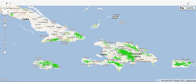
Using the 10 percentile threshold (>0.25), we estimated winter habitat to cover 33,170 km2, nearly 10% of the study area. The Dominican Republic contained half of all potential habitat (51%), followed by Cuba (15.1%), Jamaica (13.5 %), Haiti (10.6 %), and Puerto Rico (9.9 %). Nearly one-third of the range was found to be in protected areas. By providing the first detailed predictive map of Bicknell’s Thrush winter distribution, our study provides a useful tool to prioritize and direct conservation planning for this and other wet, broadleaf forest specialists in the Greater Antilles.

Maxent logistic estimates of probability of presence of Bicknell’s Thrush in the Greater Antilles. Response variables included elevation, slope aspect, land cover type, total winter precipitation, and winter mean minimum temperature. Potential winter habitat for Bicknell’s Thrush depicted in green ~1km cells using the 10 percentile training presence logistic threshold (≥ 0.25) from the best-fitting Maxent model. Click on image to view in Google Maps and download a Google Earth (kmz) file or download GIS data at https://databasin.org/datasets/538a313832bb4d3c805fa7fe8bc28983.
The amount of potential Bicknell’s Thrush habitat (km2) in protected and unprotected areas estimated from the Maxent model above (land cover, wprecip, aspect, slope, and elev). The Nature Conservancy provided up-to-date protected area boundaries for this analysis. We used both officially designated and newly proposed protected areas for our analysis as a best-case scenario.
|
% Total Habitat |
Protected |
Unprotected |
|
| Dominican Republic |
51.0 |
5,587 |
11,314 |
| Cuba |
15.1 |
1,903 |
3,100 |
| Jamaica |
13.5 |
886 |
3,600 |
| Haiti |
10.6 |
745 |
2,764 |
| Puerto Rico |
9.9 |
324 |
2,947 |
| Total |
9,445 |
23,725 |
PUBLICATIONS
- McFarland, K.P., C.C. Rimmer, J.E. Goetz, Y. Aubry, J.M. Wunderle Jr., A. Sutton, J.M. Townsend, A. Llanes Sosa, and A. Kirkconnell. 2013. A Winter Distribution Model for Bicknell’s Thrush (Catharus bicknelli), a conservation tool for a threatened migratory songbird. PLOS ONE 8(1): e53986. doi:10.1371/journal.pone.0053986.
- GIS data available from Data Basin
HAVE YOU SEEN A BICKNELL’S THRUSH?
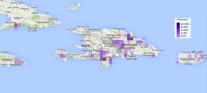
You can add your observations and see where Bicknell’s Thrush have been found throughout the wintering grounds on eBird Caribbean. Click on the map below to explore the dynamic eBird map.


